HISTORICAL SITES
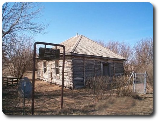 Shiloh Baptist Church
Thirteen (13) miles north of Maidstone on Highway 21, a sign directs travellers to Shiloh Church. Three (3) miles east of Highway 21 and one and one half (1 1/2) miles north will bring you to the little log church. Nestled in a small grove of trees and shrubs, the property features a one-room log building, constructed in 1912, and an adjoining cemetery.
The heritage value of Charlow (Shiloh) Baptist church and Cemetery resides in its association with the first black community in Saskatchewan, which arrived from Oklahoma in 1910. Following the American Civil War, tens of thousands of former slaves began migrating to Oklahoma Territory, where they could vote, study, and live in relative freedom. The political situation changed in 1907 when Oklahoma achieved statehood and elected a segregationist state government. As a result, a small Black Baptist congregation from Oklahoma was drawn to Saskatchewan in search of a life free from segregation and racism. In 1910, with the promise of free land in Canada's west, about 12 Black families, many of whom were former slaves or descendants of former slaves, arrived in Saskatchewan and settled in the Eldon district. These original 12 founding families were the seeds around which a community of over fifty families would grow. In 1912, they constructed their one-room log church, which they named Shiloh Baptist Church. Constructed of dovetailed, hand-hewn square poplar logs hauled by ox cart from the North Saskatchewan river, and furnished with hand-made benches and a pulpit, the church was the focal point of community life and a vital social and religious centre for the close-knit Shiloh community. The only log church build by Black pioneers in Saskatchewan, it remained in active use until the mid-1940s, by which time the community had largely moved away.
Heritage value also lies in the property's status as the only African American cemetery in Saskatchewan. Used from 1913 to 1945, the cemetery holds what is believed to be 37 graves from the Shiloh community, which, according to custom, were originally marked by large stones at the head and foot of each grave. Today, marked by white wooden crosses, the cemetery remains an important bond between the original Shiloh community and its descendants.
Nestled in a grove of tress and shrubs, Charlow (Shiloh) Baptist Church and Cemetery stands as a symbol of the Black pioneers' faith, and desire to build a better life.
The church, inside and out, is as it always was....even the benches. A plaque located near the church preserves the historical significance of the site which is visited each year by people from all over the world.
There have been numerous articles written about the church such as the 1972 article written by Ruth C. Clark for Orbit Magazine, Oklahoma City, titled "Oklahoma's N.W. Territory".
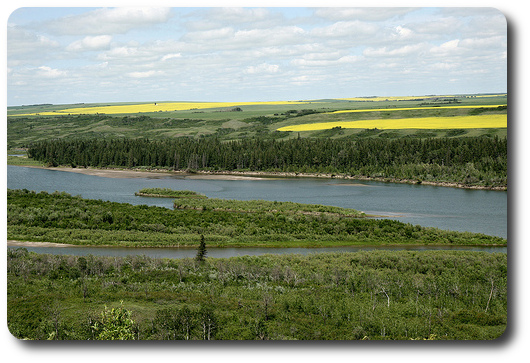 Pine Island
Pine Island is a small island, lying just off the mouth of the Gully Creek in the North Saskatchewan River. It was the site of as many as five fur trading posts between 1785 and 1793. The best known trading post was Manchester House, which was the Hudson's Bay Co. post. Fierce competition led to fighting and the end of activity with the destruction of the forts in 1793. Although the island site is inaccessible now, the view from the river banks above is breathtaking. A huge stone and plaque were erected in 1991 and provide a history of the island.
Visitors to the site, travel north of Maidstone on Highway 21 to the Silver Lake Regional Park road ( 8.5 miles) and follow this road east across the Big Gully, and then follow the signs east and south.
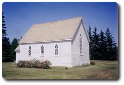 Forest Bank Church
The Anglican Church was completed in 1910 by volunteers from the congregation and is located on the southwest corner of the SE quarter of Section 14 49-24-W3. The first service on September 19, 1909 was a Harvest Festival service and regular services are still held today. The church and cemetery is located 8 miles north of Waseca and 2.5 miles east.
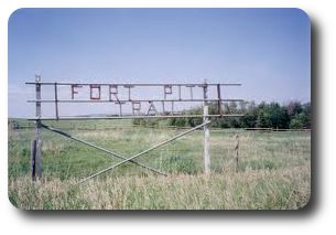 Fort Pitt Trail
The Fort Pitt Trail Marker is located 12.5 miles north of Maidstone, Saskatchewan on the west side of Highway 21. The Fort Pitt Trail linked Fort Pitt and the Battleford settlements in the 1700's. The junction of the Fort Pitt and Edmonton Trails was at Bresaylor. From Bresaylor, the Fort Pitt Trail angled northwest towards the Gully Creek crossing (approximately one half mile east of Silver Lake Regional Park), then continued northwest following a very contoured course with no steep gradients.
The Trail was the construction and service route for the Dominion Telegraph Line. With the abandonment of the Dominion Telegraph in the twenties, the trail also became obsolete in favor of a surveyed road plan. There are still traces of the Trail in the sand hill to the northeast of Maidstone. The Midwest Archaeology Society is endeavoring to preserve the remaining trail.
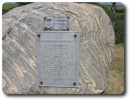 Kenderdine Memorial
In 1971, the memorial to Augustus “Gus” Frederick LaFosse Kenderdine was erected atop the Pikes Peak hill. He was a pioneer in this area and he became the first Professor of Art at the University of Saskatchewan. In 1935, he founded the Summer School of Art at Emma Lake which attracted students from all over Canada.
Gus was an outstanding artist, well respected by his peers and colleagues,preserving on canvas the original beauty of this area. His paintings can be found hanging prominently in galleries, legislative buildings and elsewhere across Canada.
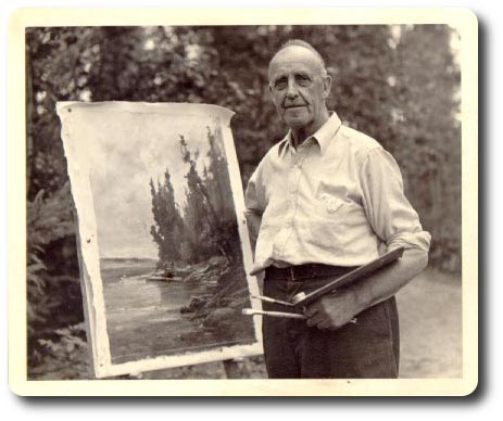
Kenderdine painting at Emma Lake.
To reach the Memorial travel, 24km North of Maidstone on Hwy. 21,then 10km West to a bend leading down a high hill. A gate on the left will lead you up this hill to the memorial and a spectacular view,a view that Gus Kenderdine loved.
Fort Pitt
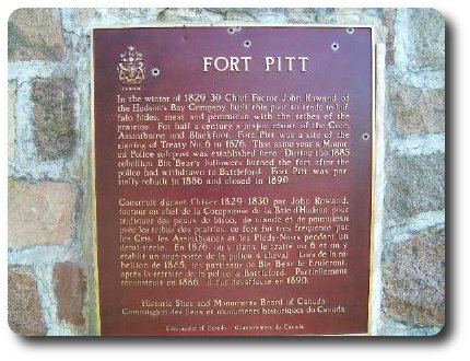
Fort Pitt, located on the north bank of the North Saskatchewan River, was also a Hudson’s Bay Company fur trade post. Established in 1829 to act as a half way point between Fort Carlton and Fort Edmonton, Fort Pitt played important roles in the fur trade, the signing of Treaty Six and in the North West Rebellion of 1885.
Today the park contains the archaeological remains of two different posts. Interpretive panels explain the post’s history and a National Historic Sites and Monuments plaque commemorates Big Bear and the signing of Treaty Six. Picnic tables, toilets and canoe access to the river are located in the park.
From Lloydminster: 30km North on Hwy. 17, 5.5km East and 3.2km North.
Wesson Memorial
The Wesson Memorial located 8.5 miles north of Maidstone, 3 miles west, 2.5 miles north, 0.4 miles east was erected in memory of John Henry (Jack) Wesson. Mr. Wesson came to Canada from England in 1907 and chose a homestead near Maidstone, Saskatchewan. From 1918 to 1924, Mr. Wesson was a director of the Grain Grower's Boards, becoming a delegate and director of the Saskatchewan Wheat Pool when it was organized in 1924. In 1937, he became President of the Saskatchewan Wheat Pool. He worked tirelessly to improve the quality of life for grain growers and was on the King's Honor List, receiving the Commander of the British Empire in 1946. He also received an Honorary Doctorate of Law from the University of Saskatchewan.
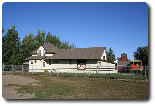 Maidstone & District Museum
This museum is a restoration of an old C.N.R station. It also includes a small village with an old country school complete with teacher, blacksmith shop, and small country church. The museum is located in the Delfrari Victoria Park.
The hours are 1- 8pm Monday through Sunday.

